Search This Blog

Friday, July 27, 2012

Small miner waiver....


        It’s that time of year again.  If you have 10 claims or less, you qualify for the Bureau of Land Management Maintenance Fee Waiver Certification Form 3830-2, more commonly called the small miner’s waiver.

         Previous years we have received a mailing that provided at least a draft of this form, but no mailing this year (cost cutting?).  The form, however, is online at the Montana-Dakota BLM site.  We just printed it from there.

         First and foremost… if you qualify for this form it must be postmarked by Aug. 31 or it is invalid.  That will mean sacrificing your claim.  It does not have to be notarized or filed at the county.


         So let’s get to work on this form.  Otherwise, you need to budget $140 for every 20-acre parcel you have claimed!

1.     This small miner waiver is filed for the assessment year beginning Sept. 1, 2012 and ending on Sept. 1, 2013.

2.     The undersigned and all related parties owned 10 or fewer mining claims, mill, or tunnel sites located and maintained on federal lands in the United States of America on Sept. 1, 2012.

3-6 are information items.

7.     The mining claims, mill or tunnel sites for which this waiver from payment of the maintenance fee is requested, are: (Here you fill in claim or site name and BLM serial number [MMC]).

          This form then needs to be signed by all claim owners (extra room on back).  Make a copy for your records and mail the original to BLM for filing by Aug. 31.  No filing fee is needed.

          If you run off the form, instructions are on page 2.

          Additional note:  If you have located a claim prevous to Aug. 31, 2012, you must either include the new claim(s) on your small miner's waiver or pay the $140 maintenance fee.  We got caught on this once and ended up forking out an additional $140 to keep the claim.  I cannot say this with authority, but we believe you do not have to have a MMC to do this, but write pending MMC on the form.

          If you are having trouble finding or printing the form, drop me an email at hillshistory1876@gmail.com and I will email you the form to print.

Saturday, July 14, 2012

Trommels, sluices, riffles


        First off, we want to clarify something we are hearing from a number of people.  Members of the Gold Prospectors of America are telling us that they are limited to hand trowels and pans in the Black Hills.  A direct quote from SD Dept. of Environment and Natural Resources, the state agency that regulates mining in South Dakota, states “Recreational mining, such as gold panning and mineral collecting that make use of hand-held equipment such as picks, shovels, gold pans, sluice boxes, or metal detectors is exempt from permit requirements. A mine permit is required for portable dredges or other mechanized equipment, even for use in recreational mining.”

        Secondly, we see a lot of innovative equipment out there.  A lot of what we see is commonly termed, “reinventing the mouse trap” or in this case, reinventing the gold trap!   Our geologist friend was a little puzzled why I use a cheap little black pan for test pans… until he saw me panning in a tiny stream and/or a tub!  That small pan doesn’t need much water, has small built-in riffles and does the trick nicely!  Now with larger amounts of concentrates, for example sluice box clean-up, choose a pan that suits your hand size and has a reasonably large inner circle circumference… allowing swirling!   

        So our conclusion would be… they all probably work, but you don’t have to spend a lot of money!  It’s the same gold, whether the equipment cost hundreds or a few $$.

        On this theme, the third item we will talk about is the tried and true, the basic concept that still works and is simple enough for someone with construction skills to build instead of buy!

        We refer to “How and Where to Pan Gold” by Wayne Winters, originally published in 1961.


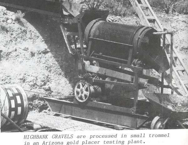
        Bob wants you to pay attention to how simple an effective trommel can be!  This is a great example of a little electric trommel simply mounted on skids with one motor running both pump and trommel.  Note the small chute at the top where gravels are dumped and then it appears they are hand-fed.  Discharge is small enough to use only a wheelbarrow, indicating how much is being fed.  The set-up of 4-5 foot cut in the gravel has set this operation up very well for recirculation of water.  Even though there’s 1000’s of holes in the punch plate of the trommel, the discharge chute shows water dripping.  This might be designed to help gravel move down the chute or could be that much water actually retained in the spent gravels.  A simple screen would save those gallons.

         This commercial trommel set up demonstrates a good scenario for riffles in the sluice.  Note that closer to the trommel, riffles become more closely spaced until they are of equal distance.  At the bottom of the sluice, the gaps are for the fine gold to settle and carry water away from the operation.  Hard to imagine any gold getting away!

         Note that sluices are lined with tin, which these days could be easily bought at a lumber yard as flashing.

         A large grizzly is set up behind the main trommel with the only conveyor being a discharge for oversized rock.  The dump truck, seen top left, is vintage but effective with haul road leading to main grizzly.  It looks like a direct dump.

         Simple but effective, the difference between a few hundred dollars and thousands!

          Good news for all interested in our Iron Creek permit... an August hearing is tentatively scheduled and we may get mining yet!

        A final note to check out Black Hills Simple Life Magazine on-line… another editorial effort in my family circle!  We did a short prospecting article this time and there are tons of interesting and informative articles on all aspects of Black Hills living!

Monday, July 2, 2012


First and foremost, Happy Independence Day! All that we love, all that we cherish, is made possible by this great American way of life!

We now digress to a more sober thought… millions are suffering the heat of summer. Power outages contribute to the problem, leaving some metropolitan areas sweltering.

We consider ourselves very lucky. For those of you who have visited the Black Hills, it is rare for the nights to stay hot. About 7 p.m., it starts to cool and many nights you are reaching for jackets in the evening and covers before dawn. Even at Rally time, yet a month away in August, we shiver to see someone riding motorcycle late afternoon into the Hills, hoping they have leather in the saddlebag. A 100 degree day quickly cools to the 50s and 60s, dipping even lower in some of those “icebox canyons” we know so well.

We’ve already had a few of those nights that fail to cool, or like last night we get a late afternoon rain shower and then it warmed back up!

This year the problem is compounded by smoke from forest fires. You hesitate to open windows in the evening when Hills fires dampen because every valley has waves of smoke drifting by.

That thunderstorm that dampens the smoke and dust puts firefighters on alert for the next spark.

Many fireworks shows have been cancelled. The grandkids are all groaning because there will be no fun with bottle rockets, Roman candles…

We’re old enough to remember M*A*S*H the first time around. This past week, it was a sobering thought each morning to hear the Black Hawk helicopters going out each morning to fight the war against fire. Each evening they returned, signaling the end of that day’s fight. The local news filled in details of casualties of the day… acres burned, homes evacuated, percentage of containment.

We’re lucky enough to live in the Northern Hills, where Ponderosa Pine are still predominantly green. That allows us to breathe a little easier, but a recently controlled fire at Crow Peak and a new fire near Newcastle keep the air smoky and all of us adults on constant alert.

So it’s 9 a.m., the a/c is on (sigh) and as we listen to the morning update on Hills’ fires, we schedule our day on what should be an August routine of things to do around home until late afternoon when we can hopefully escape the heat by driving up the gulch to a claim!


Thursday, June 28, 2012

Gold in every pan...

        It’s a legend, right? 

        Well that depends on where you go, what you dig, how experienced you are at recognizing the pay zone!

        A recent experience is worth relating to those skeptics who say, “the gold’s all been mined out of the Black Hills.”

        We have a geologist friend who, in his limited spare time, tags along to check out our current claims and new prospects.  The trip usually includes one of our located claims and one or two new prospects.

        Last weekend we stopped at an old favorite location to do a little metal detecting at the spot where we first found a nugget metal detecting a number of years ago.  Skunked, we found the usual nails, tabs, an interesting looking valve off an antique vehicle.

        We had a quick burger at Rochford, always fun, and then proceeded to one of our claims.  Now here’s where we play the wily old prospector, in that what we found there we’re not really willing to disclose location!  Let it suffice to say it was in the Central Hills and a location we are currently devoting a considerable amount of time to. 

        We drove into the area the day after a decent rain.  We gave the mini-tour and pulled over near what was probably once a holding pond for sluice operations.

        Journeying toward the creekbed, we were pleasantly shocked to see the recent rain had created a little runoff and we actually had some running water… enough for a sluice but while the guys explored I decided to try a pan.

        I hopped across the little stream, used my shovel to kick off grass and take a sample. I shoveled enough depression in the creek to pan. The first pan showed a bit of black sands and some nice garnets.

        The geologist also grabbed a bucket and concentrator and said he’d find a place to dig.

        I kept quiet until I had concentrated half of a 2-1/2 gallon bucket, panned my first pan and there were now two slightly large flecks!  I’ll have to figure a way to save garnets too, though, because they range in color from non-transparent dark to transparent red, orange toned, and pinkish.

        About then, Bob and friend migrated back my way yielding a bucket full of material.

        Bob asked, as always, did you find gold?

        Well yes, I did!  He was surprised, to say the least.  Our friend compared his material to what I was panning and it appeared similar.

        Days later, the geologist gives us a call.  He’s been working in the Hills during the day, then panning the material he brought back in the evening.

        He says he’s quite excited about that claim… he found 3-4 pieces of gold when he panned!

         I can’t stress the importance of experience.  Bob knows that area and where to expect to find gold.  The geologist might be a greenhorn, but he knows what to look for geologically in gold-bearing areas.  The final factor is shallow gravels that hold gold closer to the surface.

        So it’s there, if you look in the right area!

         Note:  We ran into some Michigan gold prospectors headed for Alaska… they got turned around at the Canadian border.  If you’re intent on Alaska gold via Canada, you might want to check requirements for entry into Canada.


Thursday, June 21, 2012

Placers and placer miners...

Alex helps demonstrate the extend of a famous placer...
bedrock cleaned back to still existing gravels.
This is in a withdrawn area... note no shovels or pans,
just a camera!


Some things never change… other things change with each gust of wind.

This couldn’t be more apparent while reading a 1933 “Report of Investigations No. 15” SD State Gological Survey by E.P. Rothrock, state geologist. He says it all in a way I often strive to communicate, and fail!

“The number and wide range of old workings lead to the conclusion that few recognizable surface indications of metal-bearing deposits have been overlooked. However, there are still chances of success for those who, with assured resources, stamina and equipment will study the record of placer mining and choose favorable regions for their prospecting.

“The gold found in placers originally existed in place as deposits of various forms in areas intruded by igneous rocks. In some cases it was deposited in the igneous rock itself in finely disseminated particles; in other cases it was originally in quartz veins, cutting through the igneous and other rocks and formed as a result of the igneous intrusions. Due to disintegrating processes (change of temperature, wind, rain, earth movements and chemical action of running water, and of glaciers in some instances), the gold-bearing rock is transported away from its source. The moving water causes the heavier gold particles to work slowly toward the bottom of the stream bed. On reaching bedrock, or hard pan, the gold moves slowly downstream until it lodges in crevices, cracks or other irregular openings in the stream bed.”

Anyway, this is a reader-friendly report and email me if you want the entire report or just search for it on the net. What I want to relay to you is the following information on the different types of placers. I hope it will help explain why superficial panning from the creek is usually fruitless or bears little gold.

Residual placers: “These are placers in which the gold is accumulated in placers by disintegration of the rock containing it. It is not transported from its original source.”

Hillside placers: “These are very old deposits, occurring on the tops and sides of hills. They may have been left in this elevated position because of earth disturbances which lifted the area above the former stream, or the original stream which deposited them may have changed its course or have meandered to a new bed. These deposits are intermediate between the creek and bench placers. Their bedrock shows no indication of benching.”

Creek placers: “The creek placers are gravel deposits in the beds and intermediate flood plains of small streams. These placers from which most of the gold has been taken constitute the best-known type of deposit. Brooks described this form of placer as follows: ’The pay streak in these deposits is usually on bedrock though it sometimes is found on a clay which overrides the bedrock. Where no clay is present the gold is found not only on the bedrock, but also where the rock is broken, the gold has worked its way down into the joints and crevices. Streams are often found to have a layer of clay on bedrock, which gradually thins out upstream and finally disappears entirely. The presence of the clay on the bedrock usually indicates that no gold will be found in the weathered rock below, as the impervious layers prevent the gold from working its way down.’”

Gulch placers: “These are very similar to creek placers, except that there is now little, if any, flowing water present.”

Bench or terrace placers: “These are more or less ancient placers, occurring in bench or terrace form, on the sides of valleys or courses of ancient streams from 50 to 300 feet or more above the present stream level. The presence of well rounded gravel is indicative of material carried and sorted by water.

Change, as we mentioned before, has been in the legal system. When this report was written in 1933, there was no state regulation of South Dakota minerals. That’s a whole lot different these days!

We conclude this blog with an oft-repeated phrase of “practice, practice, practice!” We tell newbie-prospectors this about panning, prospecting… everything!

“Technical or scientific education, although it would be helpful, is not necessary for the prospector. However highly he is educated, he has to learn by experience. He cannot, by reading books, set forth into the mountains a full-fledged prospector. A prospector, however, must have ‘courage, natural resourcefulness, good powers of observation, but most of all, tireless patience and physical energy. A new mine is not likely to be found on a summer’s holiday or a casual vacation.”

While we’re on the subject of efficient prospecting, we researched for the heck of it the Sunset Valley Mining Co. claims called the Mystics. There exists, in this section, 40 acres of ground open for mineral entry. The rest is withdrawn or private. These 40 acres, as far as we can tell from record, have been staked since 2008. Sunset Valley staked probably 80+ acres in this area. That puts 40 acres over the top of another claimholder and 40+ in a withdrawn area! Kindof hard to win in a case like this! Bob says, “That’s a mighty expensive piece of paper!”

Monday, June 11, 2012

Panning and sluicing


        Our most often read articles deal with two topics… panning and sluicing.  It makes sense, since not only are they the most commonly used methods of recovery, they are entry level “gotta have” kind of skills.

        Struggling with sluice box setup is common.  That’s why we look for an area that has not only good gold potential but a relatively easy sluicing setup. 

        Ideally, there’s sufficient drop for the 1 to 1-1/2 inch per foot of sluice box recommended and still have an additional inch or two for a rock under the bottom end of sluice.  That allows a little room for the tailings to drop out and wash away.  Eventually you’ll be cleaning out tailings with a shovel without disturbing the sluice flow. 

        A small rock dam can be built to obtain drop.  This works well in narrow streams but in a wide stream it does not need to be built the entire width, just enough to create sufficient flow to the sluice box.

        The top flare (if you have one) can nestle between two decent-sized rocks to secure the sluice in place.

        At this point, you can either dam water and seal with tailings ahead of the flare or allow free flow around the sluice, depending on the flow.  Too little water allows the sluice to clog and needs constant tending.  Too much flow carries everything right out the end!  Ideally, you have a nice ripple effect over the riffles.

        What do see most often in sluices and highbankers (permit required)?  Too much water too fast... dial it down!  If you doubt the flow, test the tailings directly off the end of the sluice.  I'll bet I could "cleanup" off the tailings and catch pans on just about every operation running in the Hills!

        So you’ve set up the sluice… throw a scoop or small shovelful (depending on size of sluice) of material in and watch how it flows through the box.  Level the sluice side to side if material doesn’t flow consistently by adding minor height on the low side.

        Now you have established a sluicing point and can add stepping stones, level a convenient bucket location, trim branches out of the way… all those things that make a house a home!

        Shovel away and enjoy the day.  But all that doesn’t mean much if you end the day by losing your gold!

        As critical as sluice box setup is cleanup.  You need to break the flow of the creek by lifting the flare end of the sluice first.  You can then proceed with cleanup.  If you do not lift the flare end first, it’s easy to dump what was in the flare right back into the creek or disturb the riffles where your gold is probably resting.

        Remove rib matting and/or carpet; clean thoroughly in a 5-gallon bucket; remove matting and/or carpet. Place the bottom end of the sluice into the 5-gallon bucket and flush concentrates with several pans of water.  Directions on this vary according to model of sluice, so we’ll keep it general! You can then transfer concentrates back to the pan for final panning.  A good hint… splashing water into an inverted bucket cleans it out quickly.

        We’ve watched a lot a people pan… we’ve panned a lot of material… DO NOT RUSH THIS PROCESS!  Remember, these concentrates are mostly heavy materials that have dropped out with gold.  Gold “riding up” with these materials is common.  Critical to the process is shaking down materials frequently and using a smooth, fluid circular motion.  

        My parents taught me if it’s worth doing, it’s worth doing right.  In the case of gold panning quality merits quantity and speed equals loss instead of gain.  Use a catch pan… it’s the only way to learn what you’re losing.

        This isn’t speed panning… leave that to the competitors.  Speed panning consists of a defined number of consistently-sized nugget-like pieces.  Your concentrates may include flour, flakes and hopefully nuggets.  I’ll just about bet it also contains black sands of some sort, nodules, bits of quartz, possibly some lead shot in hunting areas, a rusted nail or two.  You need to pay attention to the contents of the pan.

        One final word of advice… if you are encountering a lot of black sands, clean the sluice box more often or split up the concentrates to pan.  I’ve had pans of concentrates handed to me that almost dropped me to my knees (okay, I’m a lightweight!).  If you can’t comfortably handle the size of the pan or the quantity of material, grab a pan that suits you and break it into a couple of sessions.

Location, amendment and relocation

Not much entertainment here... but two blogs being posted!  So if you're not wanting to delve into this process, check out most recent panning and sluicing blog.

The location process… finding a claim is complicated enough as we’ve stated time and again. We’ve talked about the process multiple times.

So the procedure hasn’t changed much, but how many know that when you go to locate a claim there are federal regulations based on the 1872 mining law supplemented by individual state requirements?

So let’s review the federal regulations… this is going to get a little tedious unless you are specifically interested in the subject.

The Bureau of Land Management regulates mineral claims on the federal level. The Montana Dakota office in Billings, MT is in charge of the Black Hills. They state on their webpage:

STAKING A CLAIM--Federal law specifies that claim boundaries must be distinctly and clearly marked to be readily identifiable. Most states have statutes and regulations concerning the actual staking and recording of mining claims so claimants should refer to the appropriate state agency for additional requirements before locating a claim.

Prior to locating a claim, a prospector should check BLM records for prior recorded claims. Ultimately, the prospector must check for prior existing claim markings on the ground. Departmental decisions require a discovery on each claim, based on actual physical exposure of the valuable mineral within the claim boundaries. (Also, each 10 acres on a placer claim, after a discovery, must be mineral in character).

1. Claim boundaries must be distinctly and clearly marked to be readily identifiable:
We agree, but it just isn’t so! Some marks are completely outdated; others just plain don’t exist… therefore the next step is critical.

2. A prospector should check BLM records:

3. Discovery on each claim

Filing a claim, according to BLM, is as follows:

RECORDING A MINING CLAIM--Claims and sites must be recorded with both the state and the proper
BLM state office (state laws usually require filing the original location notice or certificate in the proper county office).

The Certificate of Location (COL) or notice must be filed with BLM within 90 calendar days after the date of location. Check with the proper county for their filing requirements.

A location map is required by BLM to accurately determine location and land status of the claim.

You have 60 days to file with the county in which you located in South Dakota.

BLM requires a copy of the official record of the notice or COL of each claim that was or will be filed under state law. (BLM does not require the original document, nor does the document have to be notarized.)

Do not send BLM your COL filed by the county and returned to you. Send a copy.

BLM does not require the claim information to be on any specific form, nor does BLM produce/distribute a form for such purpose. Local printing companies or stationery stores are typical sources of forms. The form submitted to BLM should include the date of location, the name and address of the owner(s), the name of the claim/site, the type of claim/site, the acreage claimed, and a description of the parcel on the ground (township, range, section, quarter section, and/or a metes and bounds description).

Be careful of pre-printed forms… we’ve ran across one or two that do not meet state requirements, one of which is distributed by a county office.

Pretty easy so far, right? We would estimate that only about 10% of those staking a claim go any further than this information. Grab a blank claim form or work from a copy of an existing form, file it and start panning!

Wait just a minute… did it say boundaries must be clearly marked? What about all the additional requirements for the appropriate state?

So we venture to South Dakota Codified Law (which we feel a little intimate with through the permitting process). Note that these laws use the word lode, but are considered by the state as guidelines for placer locations as well. It’s another technicality that we don’t want to dive into right now because it is not relevant to this discussion.

SDCL 45-4-2. Conditions precedent to filing of location certificate. Before filing a location certificate pursuant to § 45-4-4, the discoverer shall locate the claim:

(1) By erecting a monument at the place of discovery and posting on the monument a plain sign or notice containing the name of the lode, the name of any locator, the date of discovery, the number of feet claimed in length on either side of the discovery, and the number of feet in width claimed on each side of the lode; and

(2) By marking the surface boundaries of the claim.

Marking the claim is further clarified:

SDCL 45-4-3. Marking surface boundaries of claim. Surface boundaries shall be marked by eight substantial posts, hewed or blazed on the side or sides facing the claim and plainly marked with the name of the lode and the corner, end, or side of the claim that they respectively represent and sunk in the ground; one at each corner and one at the center of each side line and one at each end of the lode. If it is impracticable because of rock or precipitous ground to sink such posts, they may be placed in a monument of stone.

Most often noted error on this level… lack of posts on the ground and on the required map. Eight posts, not four, not six. Here is where the county distributed COL lacks direction, prompting for too few posts. “Substantial” is a word that leaves a lot of room for interpretation, but we do know that the US Forest Service (another agency!!!) does not like PVC pipe, steel posts and in this age of the pine bark beetle, does not want you blazing trees!

And the location certificate, as required by state law:

45-4-4. Location certificate--Recording of claim--Contents--Validity. The discoverer of a lode shall within sixty days from the date of discovery record the claim in the office of the register of deeds of the county in which the lode is located by a location certificate which shall contain:

(1) The name of the lode;

(2) The name of the locator or locators;

(3) The date of location;

(4) If a lode claim, the number of linear feet in length claimed along the course of the vein each way from the point of discovery, with the width claimed on each side of the center of the vein; the general course of the vein or lode as near as may be; and a description of the claim located by reference to some natural object or permanent monument as will identify the claim.

Any location certificate of a lode claim that does not contain the information specified in this section is void.


If, in the interest of discussion, these guidelines were taken to a court of law a large number of existing claims would be overturned. Good faith counts for a lot and the cost of contesting a claim in court is prohibitive, so that doesn’t happen all that much.


The next two items contribute to a lot of discussion at our home… amend or relocate. It’s a discussion we’ve covered in our blog repeatedly, in that an amendment preserves the original location date whereas relocation is just the same as a new location in the same place as your old location. There are few advantages to a relocation, but is a valuable tool if you have inadvertently neglected to file annual paperwork and want to retain the claim.

Feeling pretty secure in the validity of your claim? Here’s a slap in the face which we’ve seen before and we are keeping an eye on right now. Thorough research at the county (therefore state) level and at BLM in October 2011 showed a section with no claims in the area of interest. No valid paperwork or boundary markers existed on the ground. Claim staked, claim filed. Several months later (spring) an amended location certificate shows up on the ground. The amendment shows that a claim from another section staked in January 2011 is being amended to same ground covered by November claim. There are a multitude of possibilities how this may wash out. In this particular situation, we feel it’s only a matter of time until the situation fades into distant history. However, in general if there are not other problems, the amended claim would take precedence and eliminate the rights of the claim staked in November.

We consult BLM to address amending a claim:

AMENDMENTS--An amendment (1) may or may not take in different or additional unappropriated ground; (2) may correct or clarify defects or omissions in the original notice or Certificate of Location; (3) may change the legal land description; (4) may change the claim name; and (4) may change the position of discovery or boundary monuments (under Montana State law, the point of discovery cannot be moved). Amendments cannot be used to transfer ownership of a mining claim.

That’s about as ambiguous as it gets… may or may not! The guidelines are a little more clear cut, according to BLM officials, in that you can reduce the size of the claim but not take in additional acreage. We find no state statutes addressing an amendment.

RELOCATIONS--A relocation is treated much the same as a new location which essentially covers the same land as a prior mining claim/site. As such, a relocation will be issued a new serial number and date stamp.

A relocation does not relate back to the date of the prior location and is adverse to the prior location.

A relocation may not be established by the use of an "amended location notice," but requires a new, original notice or certificate as prescribed by state law.

So if you consider yourself a law-abiding citizen, look at the federal law, then look at the state statutes. Under most situations you can consider the federal law as a starting point, then go to state law for further clarification… mining or not that’s the way it works.

Tuesday, June 5, 2012

Almost there...

    The last few weeks have been a little hectic… Iron Creek placer permitting almost final!

       We have made an interesting acquaintance of another person in the permit application process, so we talk a little SDCL and ARSD (our newly-coined language revolving around South Dakota Codified Law and Administrative Rules) with him, which I think has been to the benefit of both parties.

       A word of warning to those contemplating permitting… every codified law and every administrative rule has to be addressed, and properly!  We’ve had a lot of help from Department of Environment and Natural Resources and US Forest Service staff.  They give constructive criticism to help you on your way, contrary to popular belief that they do everything to hamper the process!  These individuals did not create the law… we applaud their efforts to help us wade through the process.

        We also had the first on-site inspection at the Friday Gulch property.  We were relieved to hear that there appear to be no special, exceptional, critical or unique features and therefore feasibly shorten the permit process of that project.  Of far greater value, however, is the experience of the first permit to get our minds around what is needed.

        Left on the agenda is MSHA training and certification, final equipment roundup and hopefully some mining in July!

        Interspersed with the trials and tribulations of permitting are those days we just get out and prospect!  Those interested in claims… there is a situation with BLM regulations that may be opening up some claim areas this fall.  We can create an email waiting list for some prime placer locations, then give you a heads-up if the areas we are watching open up.  Drop us an email….

        A few hours’ outing at Boulder introduced some newly-made friends to the art of starting a dig, what to expect and how to proceed.  Their first pan of concentrates showed some pretty nice flour gold, so we think they’re headed in the right direction.

        Stream flows throughout the Hills remain fairly constant and we hope for steady rainfall to keep them running.

       We’re hearing a lot of talk about “public” lands open to prospecting.  These public lands, researched, are as often as not owned on the surface by a municipality with mineral rights reserved. 

        We also get a lot of inquiries about small highbanker/dredge permits.  We intend to put together an application that will help in obtaining that permit.  Just another project we’ll try to put together.  We’ve heard that in California they charge several thousand $$ to do this.  We’ll try to be a little more reasonable J since we would like to encourage permitting rather than circumventing the law!

        Good news is that legislation is being considered on more recreational-type mechanized mining.  Talk to your legislator about supporting the recreational miner!

       I will post a rather exhaustive blog tailored to claimholders on locating, relocating and amending claims later this week. 


Saturday, May 26, 2012

In memory...


Memorial Day… a day of remembrance for those who have died in service to our country first widely observed in 1868.

We want to take a moment to honor those veterans.

Black Hills history, in a way, was built on the backs of civil war veterans. We don’t see a lot of indications in our local history of the politics of the war, meaning on which side they fought. We do, however, see the respect given in that many of the old timers were never addressed by their given name but were called Captain, Colonel, General. It takes a little research to identify soldiers that were stationed at Ft. Meade during that era. When they visited Deadwood, invariably they were identified by rank, not first name.

And anyone who has studied Black Hills history knows the name Seth Bullock, who later served as one of Teddy Roosevelt’s Rough Riders, taking his troop to Texas.

So the Black Hills has a rich history based on the toil of the many veterans who came here to seek their fortune.

We also want to recognize some veteran prospectors we have known, regardless of their military history.

Bob had the rare opportunity to talk to a few of the last generation of old timers… men who worked the mines, alongside their fathers and grandfathers. There’s a lot of lost history buried with these veteran miners.

We find Fred Mosley listed in an old directory from 1933 -- Mosley, Frederick H. student, School of Mines. That would have been the beginning of a career culminating with a excerpt from Nuggets to Neutrinos, which credited Mosley as foreman of the Homestake Refinery.

Let me reinforce something a friend said recently… “I keep my mouth shut because I’m listening.”

Fred Mosley was “old Fred” by the time Bob got to know him in the late 1980’s. Bob listened to the old timer, and therefore he learned.

Bob’s memory of Fred goes like this: Fred liked to tell stories. One of the stories was that his father was working at the Astoria mine. The cage operator was drunk all the time and they would convince the operator to let them go to the bottom of the mine to play in the workings. Fred was 11-12 years old at the time.

Bob said one thing that was fun about Fred, he would pick a favored employee and teach them lab work and refining, telling them how to refine black slag, how many thousands of ounces of gold were there, how he had figured out how to get the gold out. Occasionally he’d come out with a pan full of rocks, pass them around and ask “ore or waste?” Then he’d turn around and walk away… He’d tell stories of assaying gold in the thousands of ounces per ton in the Homestake.

Fred was always willing to teach a willing pupil. A lot of the assayers in the Black Hills mines were taught by Fred.

Fred owned the Monarch Mine and would tell stories of taking samples and leaching, using simple sponge and battery technology to leach the material. He would tell stories of clays that you could smear on your hand and find gold.

The last time Bob saw Fred (before his death) was the Fourth of July. The 80s boom was over but Fred thought he would live forever!

This is just a sample of the lost history we hope to keep alive for future generations.

And we finish with a question to our readers. Above Mystic, as you wind down the mountain into that town, there is a gravesite marked by flowers.

We’ve asked a few people who should know… a local historian who indexes cemeteries online… have consulted local history books. We’ve found no reference. Someone knows and keeps the memory alive with flowers. Our only indication of the era is wooden markers worn to illegible near some old workings which might point to a mining associated death. It was also very common in that era for disease to sweep a community, so it can’t be ruled out that typhoid or the measles took the lives of several in a camp. Does anyone know the story?

As always, email us at hillshistory1876@gmail.com if you know this story or any other you are interested in sharing.


Sunday, May 20, 2012

Our first outing!


It couldn’t have been a nicer week… Mother’s Day in the Black Hills followed by a week of June-like weather including some really great rain the latter part of the week!

We invited friends and family to join us at the Iron Creek claim to enjoy the limited season of water and preview the claim before it is permitted for small scale mining.

It’s fun to be able to show exposed gravels and use it as an educational tool to portray how gravels are deposited through hundreds of years of erosion.

The modern-day prospector, we are finding out, is as varied as the geology of the Black Hills. The majority are there for two reasons… to enjoy the outdoors and hopefully find a little gold! To enjoy with friends, we have found, adds a rare social element of exchanging ideas and learning from each other.

So our widely diverse group consisted of a publisher, a laundry owner and her two adult sons, an equipment contractor, our trusty mechanic, a geologist, a couple of our more mature friends, two grandkids… all in all a nice representation of ages and trades!

Some feedback from our friend Pat:
“This past mother’s day was fun and different, no usual restaurant dinner with crowds of people packed in the restaurant foyer waiting for a table, kids crying and racing around bored with all the waiting… instead we were invited by our friends Bob & Teresa to share digging and sluicing at their Iron Creek claim with their family and other newbie prospectors like ourselves. We threw a few sandwiches and drinks in the cooler, gassed up the jeep and headed out for the fun. After greeting the others that were there ahead of us (we were late getting there due to the boys and I having a difference of opinion on which way to turn and back tracking a little), the boys met Teresa & Bob’s grandson and they went off exploring, looking at long dead deer bones and stuff like boys will do, while I visited with Teresa and others.
“Then it was time to get into the dirt, my youngest took over from me and said he wanted to dig, so he and my older son filled a few buckets wherever a good hole or hill was pointed out to them and I asked Teresa for a few lessons in how to set up the sluice and the correct way to pan. It’s s good thing she showed me how since I would not have known how to fill in by the head of the sluice to make it flow like it should, and I need to be more patient with my panning I learned. I can see I was rushing the process too much. Hands on learning is always better than going by the books or the internet! And so as far as ‘mothers days holidays’ go, it was definitely one of the most memorable ones! Thanks, Teresa & Bob for the invite and for sharing your digs and lessons! “

We also spent two days prospecting… one at Little Deer Creek, the other in the Mystic area and doing some mapping at Friday Gulch. A few sprinkles lifted our mood… nothing like the smell of rain mixed with pine to gladden the heart!

This weekend included locating a 20- and 40-acre claim west of Custer. One is purely recreational, the other with a permit in mind.

The upcoming week includes an on-site inspection at Friday Gulch with the hope that no scenic or unique characteristics surface! We always enjoy talking with state and federal representatives… and never fail to learn something!

We’ve also found some very interesting properties to further check out… might be able to add up to 100 acres of prime prospecting to our holdings!

Friday, May 11, 2012

Where would you dig?


This photo is so classic… a beautiful Black Hills creek highlighted by a large boulder!  I'd buy this claim is it was advertised on the internet (which is isn't!).

Both a recreational and more experienced prospector would appreciate this scene, but where would you dig?

We’ve talked about this before… what all the handbooks say to look for before digging. But this photo is so perfect to represent what we have tried to portray verbally!

Before you sink a shovel, take a closer look and I hope it is visible enough for you to see! There’s a great sluicing spot here with enough drop to make setup a breeze!

There’s a huge boulder in the creek, right? Are you going to start there, like the handbook prompts?

Closer inspection shows a deeper “pond” behind the boulder. Now you can dig there and find a lot of silty material and if you dig deep enough, probably some gold! But the pond tells you a story that you need to listen to closely. Others have seen that boulder and commenced digging behind it. That’s why the pond is there! It’s several feet wide and stepping into it with boots you sink into the silt another 3-4 inches. That means you would muck out probably a foot of accumulation before you might encounter a layer dense enough to retain even a fleck.

It does, however, make an ideal panning spot below but close to the sluice box!

So you look to the inside of the bend, which in this case the photographer is standing on. Pretty little wildflowers (wild irises about now) decorate a small landing area perfect, we have found, for lawn chairs, lunch supplies and drinks! Why do we place our camp here instead of digging? It’s tailings, washed down the creek throughout the years! Again, a fleck might be found, but that would destroy the camp area!

So directly in front of you, on the far bank, would be a hillside digging site. Not unique in the Black Hills, this stream was worked commercially at one point in time. Everything that was ejected from that commercial venture lines the creek on that side! Again, a fleck or two for several hours of digging!

So we are again encouraging you to “think outside the box,” or in this case the creek!

We’ve spent 10 years on this claim. We’ve tried every classic approach… now I’m going to show you what we discovered!

Up over the bank from the creek about 30-40 feet is a large pile of overgrown material. Early in the years when we acquired this claim, Bob said, “Try digging here!”

It’s been our sluicing “stockpile” for 10 years. We think the historic claim ended about here because the stockpile was pushed up and never worked. Pushed up from where? A pit dug directly adjacent to it! We can usually count on a decent “picker” in a few buckets of material.

So we work the stockpile on lazy days, shaking out a little gold.

Not nearly as pretty
but that's where the gold is!
One last addition to this conversation that I think only the more experienced prospector would think about… the pit under the stockpile! It takes a little work, removing a foot of topsoil, digging down into gravels that sport everything from rounded rock to clay to boulders that take a bar and two men to move.

Eventually, though, a fine layer of reddish cemented gravel is reached and then, then I can reasonably expect a show in every pan!

If you’re an experienced Black Hills prospector, that’s a good pan!

So it’s your choice… a panful of discouragement or a panful of satisfaction!


Tuesday, May 8, 2012

the new prospector... a woman?


We haven’t talked about female prospectors much, and being the weekend before Mother’s Day I thought it a good time to discuss an email from Pat about the subject:

The reason I ask about female prospectors is that I do get a rather amused look by people when they find out I like to pan. Some though, don't think it odd, but I have yet to meet another woman other than yourself who actually does any panning/prospecting. I have had a few who wanted me to bring them along, but I doubt they would want to get wet or muddy, or dirty their hands.

Men seem less surprised then women friends I know.

I had done a little looking into how many female miners were out there, and apparently there are not that many now or historically.

I ran across several references that mentioned women were considered bad luck around mines until the 1970's, but also that occasionally women often worked beside their husbands on placer mines but it was considered a bit odd.

I did not find reference to any women miners in South Dakota except for Sarah Campbell "Aunt Sallie", who you are probably familiar with since she lived up in your neck of the woods.

Pat attached this quote: :"During Custer's Black Hills Expedition, she (Aunt Sally) and 20 other Bismarck residents formed the Custer Park Mining Company and staked placer claims on French Creek, now part of Custer State Park. When the Black Hills Gold Rush began in 1876, Campbell joined the second outfit from Bismarck to head for the region. She lived in Crook City and Galena, both mining towns on the western border of modern-day South Dakota, and continued to work as cook and midwife while she prospected. She searched for both gold and silver and filed five claims, although the Alice Lode silver mine in the Black Hills was the only one that proved valuable. Fifteen months before her death, she sold it for $500.."

I also found some interesting stories about woman miners in Alaska, California and Nevada and Oregon who defied cultural limitations to mine for gold. So it looks like we are a rare breed! TTYL--Pat

A rare breed indeed! My (Teresa) experience is just as Pat explains it… a lot of enthusiasm until it’s time to get dirty!

Pat has two sons who help her out. Bob and I have raised our first generation of three girls and one boy prospecting along side us. Ironically, two of those girls still show a lot of interest in prospecting. Our grandkids, three in residence, are two boys and one girl. One boy and one girl have a real interest… one would rather climb rocks!

Another email friend, Joel, has told me repeatedly that his daughter really loves prospecting!

So I think the future of prospecting includes at least four more women, not to mention several email inquirites I have addressed from female prospectors!


Tuesday, May 1, 2012

Research...


      We’ve talked before about how we go about researching an area… past experience, historical reference, LR2000 and BLM Glo, just to mention a few steps we take.

         Conversations invariably turn to, “but how do you find a claim!”

         Bob knows the history, the geology, and we’ve prospected just about every gold-bearing stream in the Black Hills.

         But… there’s a lot of terrain out there!  That was reinforced recently by a geologist who knows the Hills, but doesn’t have the time to pull information on each area he is interested in!

The "perfect" placer... even
conveniently marked boundaries as indicated
by Forest Service marker upper right!
         One prime claim we recently obtained is credited solely to Bob’s research.  The Keets Mine incident, if I properly recall, prompted him to look again at areas surrounding Lead and Deadwood.

         Bob reads me a “someone in that upper Deadwood Creek area finally found a good gravel bench and cleaned up a large amount of gold… considered ‘hitting it big’.”

         Then he recalls some U.S. Forest Service “gaps” among the private property.  The search is on!

        By the way, we staked a lode claim on this property and are contemplating sale to rights for a placer.  Fair warning… this will not be cheap and we may resort to a bidding-type situation.  We could search our lifetime and possibly not find a comparable placer claim.

        That is one way to find a claim, but unless we stab a finger at the map and start research, it would be a 24/7 job to research just the gold-bearing streams!

        That’s why we encourage those contacting us to procure a claim to isolate the area they are interested in.  We let them do the map stabbing and we go from there.

         We’ll use a recent experience to let you know how it works.  We were contacted by someone who likes to do a little fishing and told us about some recent expeditions, wondering if any claims were available in the area.

        In the past, we’ve been contacted for like information “where I hunted,” or “where I hiked”.  That’s the map stabbing that gets us researching.

        Each time, without fail, something shows up!  This time it was some claims that are about to be declared invalid by the Bureau of Land Management.

         So if you want a claim, it’s probably out there.  The one area we eliminate from most requests right off the bat is Iron Creek.  We have a claim there, why shouldn’t others?  Our claim pre-dates huge blocks of lode claims.  Contrary to how this appears, you can’t stake a placer over existing lodes… even though they staked lodes over our existing placers!

        On the agenda this week is further exploration of the upper Deadwood Creek claim.  I’ve already panned out flour gold my first test pan; we’ve identified lode deposits; now we want to spend some real time exploring!  Sounds kindof silly, but we don’t have that many claims with good quantities of flour gold and find it just as exciting to see a “rim” of gold when we pan as to find flakes, pickers and nuggets!

Monday, April 23, 2012

If they could see us now...


An email from Joel prompted this blog… what would the old timers think?

He was talking about the “gold hog” matting recently released for retail sales. He said, “Tested gold hog mats with SD material, quite impressed.” He then speculated, “If the old timers had some of the new stuff, it’s hard to say what they would have defined as wages on a placer.”
I replied, “I am thinking about those old timers looking into the future with our sluices, 4-wheelers, a metal detector... they would certainly call us a bunch of pansies!

So I envisioned the traditional prospector from gold rush era. There was usually a mule loaded with a pick-axe, gold pan and a shovel. Anything else they needed they used local resources to make. There’s still a few remnants of old sluices here and there in the Hills. They look to me, a lightweight, to need at least two men to transport them. I suppose that’s why the remnants are still visible… they’d just build a new one when they moved on. By the way, they started with felling a tree, not buying wood at the hardware store!

Some of them would take their metal pans and bang riffles into them… I can almost hear it echoing around the campfire!

And what a solitary existence… our prospecting is a family and friends outing! If the old timers got a pouch of dust and nuggets, they had to be pretty careful to not only guard their gold but not let anyone know the source. No wonder they trusted only their mule!

Gold Bug Nelson as portrayed
in "Gold Pans and Broken Picks" by
Christopher Hills.
We take a lot of things for granted. We load up our prospecting supplies in a 4-wheel drive vehicle, stop at the local convenience store, gas up and grab some drinks and sandwiches and drive to our claim. We set up our lawn chairs, unload prospecting supplies and get digging.

If we camp at the claim it’s in a camper with a stovetop to make our morning coffee. I love campfire coffee, but it’s sure nice to have an instant flame! The frig is stocked with whatever we want to eat and there’s a heater if the evening gets too chilly. The camper is also great refuge from storms.

So maybe that has more to do with modern-day recovery methods than anything… I don’t want to work real hard, a good cup of coffee is more important than the weather because shelter is right there.

Now with all the conveniences we enjoy so much, you’d think we would recover a lot more gold. But to recover gold you’ve got to put in those back-breaking hours, no matter what. I’ll just about guarantee that the old timers did a lot more digging and recovered a lot more gold in a day’s time!


Thursday, April 12, 2012

Safe and sane...


Pine bark beetle damage.
The Black Hills are at risk! Sound like some doomsday prediction?

I’m going to post this as an “extra” blog because I figure some will accuse me of nagging… but I can’t stress how critical this issue has become.

The current year “2012” poses some intimidating scenarios in the Black Hills. There’s a lot negative going on with pine bark beetle infestation growing at an ever-increasing rate. The far-reaching consequences of tourism and timber, therefore the economy, are devastating to contemplate.


We want to stress the importance of safe thinking in the forest. Man-made fire of any sort is a risk. Our worst August weather under normal conditions cannot compare to the risks we see building as spring breaks here in the Hills.

Red tops of the last season, stark black silhouettes of a former Ponderosa Pine… the fire danger is already extremely high. We’re usually cautioning everyone about spring flooding. This season it is a double-edged sword. If you go into the woods, don’t put yourself at risk by being in a remote location that has no alternative escape route. If it floods, you’re stuck… if a timber fire starts, you’re burned out!

As children, Bob and I learned that you don’t have much of a horizon or “window to the weather” in the woods. You might not hear thunder or see lightning until the storm is almost on you, then look out! The same can be said for flood or fire, whether man- or nature-made.

But the bigger picture needs to be considered. When trees die, erosion increases.

The plus side of that for a miner is that increased erosion deposits gold in the creeks. It also exposes bedrock and rock outcrops. We try to find something positive in everything and that’s about the only positive note to the beetle story!

The minus side of erosion means increased flooding of trails and roads, culverts and bridges. It means that all that soil held in place for the age of the forest might move, and move big! This year we will begin to see consequences. Out of necessity, areas are being more or less clear cut to try and stay ahead of the bugs.

Please be cautious. Logging trucks are everywhere. I don’t know if you’ve ever been around a logging operation, but these guys get paid by the ton. Needless to say, they don’t anticipate meeting much traffic on a logging trail. They’re thinking about how much time is left in the day, not how many cars they might meet!

If you’re going into the woods where “bug trees” exist, carry a saw to be sure you can go out. It doesn’t take much wind to bring a dead tree down!

Avoid parking in tall grass, especially since we didn’t have enough snow to “lay down” last summer’s undergrowth.

Any spark… from a campfire to heavy equipment, can start a fire.

Cell phones don’t get a signal in many parts of the Hills, so don’t rely on being able to call for help. It might mean a hike to the highest peak in sight before you get a signal.

If you do see a lightning strike, try to assess the fire potential, then get out and report it! Fire lookouts in the Black Hills are, I believe, usually staffed primarily in the summer. They will spot fires and report them, but outside of the season the watch may not be as active. Irregardless, I’m thinking as early as a potential fire can be reported, the better!